French Guiana is known mainly for its jungle and hiking. Yet, when Googling “how to get to the Rorotá trailhead,” I could not find an actual address. My map put a pin on a street with “Rorota” in the name that looked like it was at least in the right area, but we still weren’t 100% sure. SPOILER ALERT : it was definitely the trailhead.
Getting There
From Montabo, Cayenne (where our Airbnb was) it gave us an ETE of about 2 hours and 40 minutes walking. The driving ETE is less than 40 minutes. So, Michael and I started walking and crossing our fingers that we could hitch a ride. About an hour in, an older gentleman pulled over to us and said he could take us closer. His English was pretty good for using it 50 years ago, and even though he didn’t know exactly where we were headed, he seemed to have an idea. As we drove, he even pulled over to ask someone directions!
We got closer and eventually passed the street that my gps told me to go to. I looked at Michael, showed him the map, and mentioned it to the guy. He said we were definitely on the right path. I won’t bore you with details, but a few phone calls in French and a U-turn later, we were headed back toward the pin. Our new friend even had someone find us to lead us to the entrance and we made it!
View from the van•Entrance to the fake trail
Jk, not it.
The guy was excited we made it, and kept telling us to “pay attention.” This entrance was on the side of the road with a water spigot. As we soon found out, he was warning us because it is a VERY broken trail that was extremely frustrating to find / navigate. This particular entrance had no signage, no directions, and no markers. After a little climbing around and not seeming to find what was supposed to be an easy trail, we retreated. The original pin I had was a 30 minute walk from our location, so we decided to try it out.
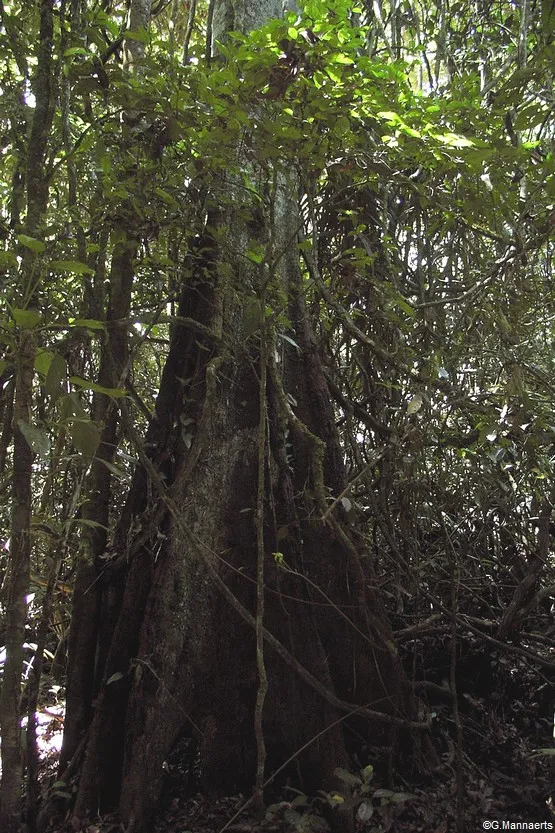
If you see this, you've gone too far...• Michael with a giant tree
The Trailhead
Violá! The mysterious pin had lead us straight to the Rorotá trail parking lot, with signs and everything. The crazy part is that on the main road, someone ran over the sign that literally says “Sentier du Rorotá” and has a little hiker dude. We found it laying on the ground and realized why we couldn’t see it when we drove by (facepalm). In case you want coordinates instead of guessing : Latitude 4.8875 ; Longitude -52.2625. Or simply google / type into your gps “Sentier du Rorotá” and it should get you there.
(Located between Rémire-Montjoly and the port of Dégrad des Cannes, it is accessed via the beach road. Heading towards Dégrad des Cannes, a small road branches off to the right about 3 kilometers from the intersection with the Route des Rémire. This circuit provides an easy and pleasant approach to the Guiana forest. The steep trail winds around the Mahury massif (149 m), skirting lakes and penetrating a lush forest before ending with a bamboo-lined path. In places, it offers exceptional views.)
Turn here!Just rude...Parking lot
Trailhead info here Signs
The Rorotá Trail
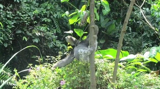
I kid you not, less than five minutes into this hike, we saw a wild sloth within arms reach! This was the only reason I even wanted to do this hike, so I was stoked. It was cute, and awesome, and took every ounce of self control I have not to touch it. After getting a million pictures, we kept walking up the trail until we reached a T.
Right or Left?
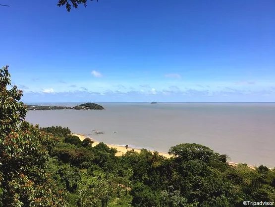
Since the trail is a loop, it doesn’t really matter which direction you start in. However, when we reached the end, I was glad we started to the left. It starts off nice and easy with a pretty flat, low-grade incline. As you walk around, it gives a nice view of the ocean and then starts to turn into more jungle-y terrain before returning back to the start. I also noticed that the majority of people seemed to take the left as we all walked the same direction.
Sign at the T• Left turn•Jungle•Ocean view• glad steps were here
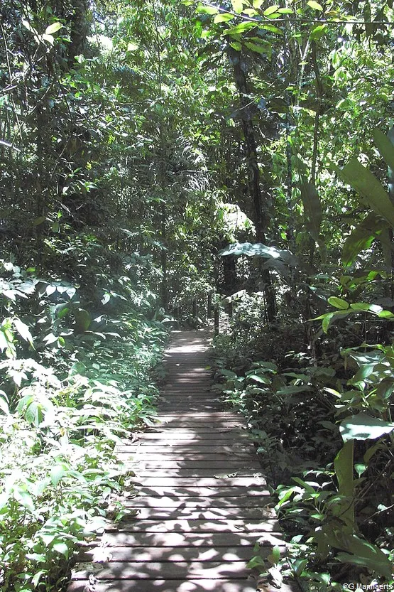
The Trail
There are incredible amounts of diverse insects, animals, and plant life to be admired here, but be careful if you decide to hike after it rains. A lot of the Rorotá trail consists of this clay-like dirt that becomes incredibly muddy and slippery when wet. I wore my famous hiking sandals and was perfectly fine for about 98% of the trail. Listen to me when I say though, this trail can get very muddy and stick to your shoes pretty well. This causes it to become slippery, so be prepared. We were also warned of falling trees, rock slides, and snakes, but did not encounter any during our time there. Including stopping to admire nature and snap some photos, it took us 1 hour and 45 minutes to complete the Rorotá Trail.
Like it? Pin it!
What was your experience with this trail? Hopefully not as hard to find as ours… But hopefully just as enjoyable!
Ce département français qui borde
Ce département français wui borde
l'océan atlantique, offre de magnifiques paysages et des forêts qui valent la peine d'être vues. Cette petite région française est située entre le Brésil et le Suriname. Il n'est donc pas surprenant que 90% de son territoire soit recouvert de forêt amazonienne. Si vous aimez l'aventure et découvrir des lieux hors des sentiers battus, le circuit du Rorota, à la sortie de Cayenne, est fait pour vous. ( This French department, bordering the Atlantic Ocean, offers magnificent landscapes and forests worth seeing. This small French region is located between Brazil and Suriname. It's no surprise, then, that 90% of its territory is covered in Amazon rainforest. If you enjoy adventure and discovering places off the beaten track, the Rorota circuit, just outside Cayenne, is for you. )
Rendez-vous sur le Mont Mahury (Meet at Mount Mahury)
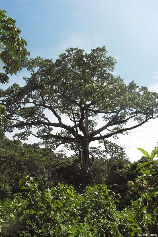
Proche de la ville de Cayenne, s'élève le Mont Mahury. Culminant à 162 mètres de haut, il fait partie des dernières zones naturelles encore préservées de la région. Pour profiter au mieux des richesses naturelles de la Guyane, aventurez-vous sur le sentier du Rorota. ( Near the city of Cayenne, rises Mount Mahury. At 162 meters high, it is one of the last preserved natural areas in the region. To fully enjoy the natural riches of French Guiana, venture onto the Rorota trail. )
Ce parcours ombragé, aménagé par le Conservatoire du Littoral, vous permettra de découvrir une diversité de paysages et de panoramas entre forêts et lacs. Accessible en voiture depuis la route des plages de Rémire-Montjoly, ce circuit au dénivelé modéré est un concentré de ce que la nature guyanaise offre à ses visiteurs. ( This shaded trail, developed by the Conservatoire du Littoral, will allow you to discover a diversity of landscapes and panoramas between forests and lakes. Accessible by car from the Rémire-Montjoly beach road, this moderately incline circuit is a concentration of what Guyanese nature has to offer its visitors. )
Cette promenade autour du Mont Mahury décrit une boucle d'environ 5km. Ainsi, vous pourrez rejoindre le plateau de Mahury depuis l'anse de Rémire ou l'habitation du Diamant. Parcourir ce sentier vous prendra environ 2h30. ( This walk around Mount Mahury describes a loop of approximately 5km. You can reach the Mahury plateau from Anse de Rémire or the Diamant habitation. This trail will take you approximately 2.5 hours. )
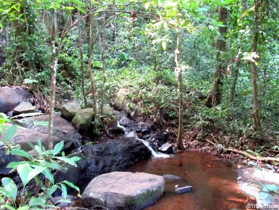
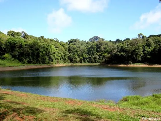
Sur votre chemin, vous aurez l'occasion de découvrir trois lacs naturels : le Rorota, le Lalouette et le lac de Rémire. Utilisés pour approvisionner Cayenne en eau potable depuis la fin du XIXème, ils ont été progressivement agrandis et aménagés. (Along the way, you'll have the opportunity to discover three natural lakes: Rorota, Lalouette, and Lake Rémire. Used to supply Cayenne with drinking water since the end of the 19th century, they have been gradually enlarged and developed.)
Découverte de la faune et de la flore guyanaise (Discovery of Guyanese flora and fauna)
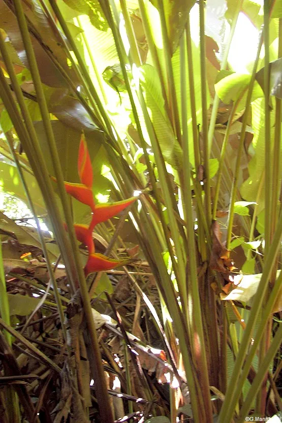
Cette visite en terre équatoriale vous permettra d'observer la flore typique de l'Amazonie. De grands arbres, des plantes multiples et des fleurs aux couleurs chatoyantes font de cette région un terrain de jeu idéal pour les animaux qui y vivent. (This visit to the equatorial land will allow you to observe the typical flora of the Amazon. Tall trees, diverse plants, and brightly colored flowers make this region an ideal playground for the animals that live there.)
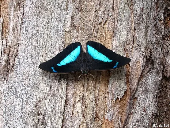
Ainsi, votre promenade sera ponctuée de rencontres avec de nombreuses espèces. Les plus visibles sont les morphos. Ces jolis papillons bleus sont typiques de Guyane. D'une envergure de 12 à 20 cm, ils vous surprendront par leur audace et leur beauté. ( Your walk will be punctuated by encounters with numerous species. The most visible are the morphos. These pretty blue butterflies are typical of Guyana. With a wingspan of 12 to 20 cm, they will surprise you with their boldness and beauty. )
Si vous souhaitez voir des moutons-paresseux, le Rorota est idéal. En prenant le temps d'observer autour de vous, il vous faudra repérer leur arbre de prédilection, le bois-canon. Cet arbre tient son nom de son tronc creux qui explose lorsqu'on le brûle. Au milieu du feuillage, accrochés le plus souvent la tête en bas, vous distinguerez peut-être ces gros mammifères à trois doigts. Grâce à l'algue verte qui se développe sur leur fourrure, ils se font plutôt discrets et attendent paisiblement que le temps passe. ( If you want to see sloth sheep, Rorota is ideal. By taking the time to look around you, you will need to locate their favorite tree, the bois-canon. This tree gets its name from its hollow trunk that explodes when burned. Amidst the foliage, most often hanging upside down, you might spot these large three-toed mammals. Thanks to the green algae that grows on their fur, they are rather discreet and wait peacefully for time to pass. )
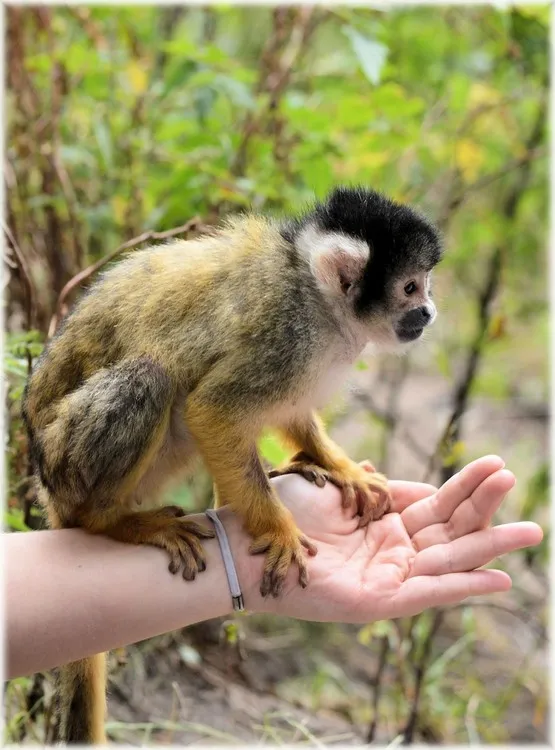
Si au-dessus de vos têtes vous sentez du mouvement, c'est que quelques sapajous vous surveillent. Ces singes-capucins peuvent chercher à vous effrayer mais sont inoffensifs. Ils partagent l'espace avec les singes-araignées, appelés kwata ou encore avec les singes-écureuils connus sous le nom de saïmiris. ( If you feel movement above your head, it means that some capuchin monkeys are watching you. These capuchin monkeys may try to scare you but are harmless. They share the space with spider monkeys, called kwata, or with squirrel monkeys known as saimiris. )
Les sous-bois sont parfaits pour observer les oiseaux et les insectes. Les végétaux qui y poussent les attirent et la nourriture y est bien présente. Colibris, cotingas ou toucans s'y promènent en toute quiétude et offrent aux visiteurs une variété de bruits et de couleurs. ( The undergrowth is perfect for observing birds and insects. The plants growing there attract them, and food is plentiful. Hummingbirds, cotingas, and toucans wander peacefully here, offering visitors a variety of sounds and colors. )
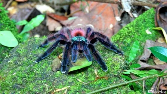
Regardez bien où vous marchez ! Ne partez pas en courant si vous voyez une grosse araignée velue. Il s'agit sans doute d'une Matoutou. Cette mygale-star de Guyane est inoffensive et facilement reconnaissable à ses extrémités orangées. • ( Watch your step! Don't run away if you see a large, hairy spider. It's probably of a Matoutou. This star tarantula from Guiana is harmless and easily recognizable by its orange extremities. )
En prenant votre temps, votre promenade sur le sentier du Rorota sera un beau moment de découverte de cette région amazonienne pleine de surprises. • ( Taking your time, your walk on the Rorota trail will be a wonderful moment of discovery of this Amazonian region full of surprises. )
慢慢地,沿着罗罗塔小径漫步,您将会发现这个充满惊喜的亚马逊地区的美妙时刻。Màn man de, yánzhe luó luó tǎ xiǎojìng mànbù, nín jiāng huì fāxiàn zhège chōngmǎn jīngxǐ de yàmǎxùn dìqū dì měimiào shíkè.